File:Holy land USA.png
Jump to navigation
Jump to search
No higher resolution available.
Holy_land_USA.png (187 × 270 pixels, file size: 104 KB, MIME type: image/png)
Summary[edit]
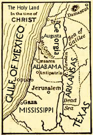
A mapping of the Middle East substituting Bible Belt states for countries.
Licensing[edit]

|
This work is licensed under a Creative Commons Attribution-ShareAlike 2.0 License. |
| You're welcome to have your way with it, but only under those terms. Have a nice day. | |
| CC-BY-SA | |
File history
Click on a date/time to view the file as it appeared at that time.
| Date/Time | Thumbnail | Dimensions | User | Comment | |
|---|---|---|---|---|---|
| current | 01:27, 31 December 2014 | | 187 × 270 (104 KB) | Phrank Psinatra (talk | contribs) | A correction of the original mapping of the Middle East |
You cannot overwrite this file.
File usage
The following page uses this file: